Introduction
These diary entries cover my Pennine Way walk in April 2006. Unfortunately my camera was the victim of torrential rain and none of the pictures on the memory card survived to make it to the diary.
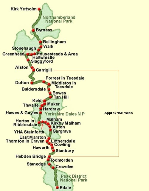
I walked the middle section of the Pennine Way, shown on the map below.
Tuesday May 2 Arrival at Hebden Bridge
Its a wet and cold day in a cemetary, what a way to start a walk, but my search for David Hartley, the famous “coiner”, was successful. I am standing over his grave in the Heptonstall churchyard cemetery where he is buried along with five family members all under one gravestone. I suppose they are tucked in together to save money. My other quest here, the grave of poet Sylvia Plath, is locked away within the church. Oh well, another time!
I had flown from San Francisco, arrived in Manchester early in the morning and took the train from Victoria Station for the two hour trip to Hebden Bridge where I had chosen to jump onto the Pennine Way. I’ll be walking the middle section of the PW, 150 miles north to Alston, approaching Hadrian’s Wall. For the ten days of the walk, the average ascent and descent is 2200 feet through quite a bit of uninhabited country. I’m carrying 14 pounds in my backpack, everything I’ll need since I’m staying at B&Bs or hostels every night and eating in the pubs. I took some wonderful photos with a new digital camera, but sadly, all were lost. More on that later.
It was a steep, steep climb up to Heptonstall, a small village on meadow land high above Hebden Bridge. The nice lady at the TI in Hebden Bridge had turned me onto the story of Hartley who scraped by in the 19th century by scraping gold off coin edges until he was caught. After my grave hunting, I stopped in the village pub for a pint of Timothy Taylor Landlords ale, then off down the road to find the PW path which would lead to my B&B for the night. There was no sign of the path, so I asked a fellow who pointed me through the fields on the route his kids took to Colden Water. After a non-intuitive jig and jog through the fields, down steep stone steps to Colden Clough and crossing the beck on an old packhorse bridge, I climbed up Pry Hill fighting a fierce wind with rain and finally arrived at Badgerfield Farm.
Miriam had been looking out for me and greeted me with press coffee and chocolate cake in the lounge. After this, all I wanted was a hot shower and a long sleep to get my body over jet lag. I can hardly keep my eyes open writing in my journal as the windy storm pounds against the window.
Wednesday May 3 Badgerfield Farm to Cowling
Sunlight was streaming through the window. I looked outside and all was beautiful, a flower garden below and, to the south, Stoodley Pike framed against the blue sky in the distance. Last night’s storm was past.
From Miriam’s breakfast menu, I chose cheese and mushrooms with scrambled eggs. Miriam is a great host and cook and the food set me up for the day, but the coffee needed help. I backtracked to the Heptonstall road where yesterday I had trouble finding a PW waymark. No, there isn’t one! But I found the waymark when crossing a smaller road 500 yards further on. I took a photo but as I said it is now lost. Uphill onto Heptonstall moor, bleak, boggy, lots of ups and downs. Passed Lower Garple Reservoir, crossed two footbridges over a beautiful spot where Reaps water meets Graining Water, then on to the three Walshaw Dean Reservoirs.
Here I made a turn too soon, turning uphill at the second reservoir instead of the third. This misreading of the map cost me an extra three miles and an hour. Not fun! I’m probably the only walker who has ever done this. Luckily, a farmer set me right and told me of a little shortcut to boot. On track again, up and over the stone slabbed boggy moor to Withins House, the inspiration for Withering Heights. Lovers of Bronte novels from all over the world visit this ruined site. Here I had lunch of bread and sausage (saved from breakfast) and visited with two chaps who were out walking and fishing.
The track then led to Ponden Reservoir and past elegant Ponden Hall which seems to have accommodations for walkers in an adjacent building. After crossing the bridge, I climbed uphill through pastures and past Far Dean Fields Farm, where I stopped to refill my water bottle at a spring supplying water to the farm. Then on to the real moors, Ickornshaw Moor, desolate, brown and boggy. Ten years ago, they started putting stone slabs on the path over the bogs. These slabs came from the floors of old disused woolen mills and are brought in by helicopter. They made it easier to negotiate the watery, sloggy bogs, but are hard on the feet. Take some, give some! I hate to think of how tough it must have been to cross here without the slabs. Finally, out of the moors and past old farms where I reached the road into Cowling and Woodland House B&B. It was 6 pm and my hosts were beginning to worry.
Susan and Sandy greeted me with hot tea and shortbread and were eager to chat. They recommended the Harlequin restaurant for dinner, just down the road. This was quite a nice place. I had Timothy Taylors Landlords and a wonderful plate of lamb fillets w/red wine au jus and scalloped potatoes. Just fantastic! The young couple sitting next to me drive 15 miles to eat here because the food is so good.
My room at the B&B is comfortable and roomy, very luxurious compared to last night. I write, read and study my guidebooks for tomorrow’s walk. I’m using Wainwright’s book for it’s superb detail and also Hopkin’s book for its more generalized macro approach and up-to-date maps. I fall asleep in a wonderful double bed. Nice!
Thursday May 4 Cowling to Malham
There is a promise of sun and a warm day, but it started off cloudy and hazy. A lady walker was asking directions of a local so I stopped and talked with her briefly and pointed the way. She was ahead of me yesterday but took a wrong turn at Ponden Reservoir and I wondered where she was heading. She is walking from Land’s End to John O’Groats, the full length of Britain. Whew!!
Over hills and fields to Lothersdale, then up over Thornton Moor to Thornton-In-Craven where I ate a banana on the village green with the John O’Groats (JOG) lady. The sky is clearing. More high hills, then down to meet the Leeds & Liverpool Canal. Walking along the towpath is a pleasant change of pace. The boats anchored here seem to be mostly owned by retired people. Of course, I passed under the famous double bridge, the upper one built to accommodate modern traffic. After leaving the canal, I lost the path and had to backtrack to a footbridge that I knew was on the path. Hopkins skips over details so it is easy to lose where you are, but I could locate my mistake by studying Wainwright’s detailed maps.
At Gargrave, I refilled my water bottle at a pub and left town on a country road. While crossing a pasture, the path completely disappeared. I came to a fence, but no stile. Where to go? Then I spotted several walkers coming my way across a distant field and I could see where they would meet the fence. I turned right along the fence until I came to a place to climb through and rejoin the path. Later, I was dive-bombed by a squawking bird who was protecting her nest in the grass near the path. But really! She should be used to walkers by now. The walk was delightful along the River Aire to Hanlith Hall where I met two girls practicing their horse riding techniques. They said I should go to Kirkby Malham instead of Malham, “its a better place to visit”. Maybe another time. Its a steep climb on the road past Hanlith up onto picturesque cliffs over the river, then down into the village of Malham.
Mirefield B&B is a nicely restored old building, fairly comfortable, but with a commercial feel to it and an abrupt manager. The village is incredibly picturesque, bisected by the river and has two lovely connecting bridges. The Lister Arms was highly recommended and has a great selection of ales, but the menu was uninspiring. Eating with a couple doing the Malham circular walk, I had Timothy Taylors Landlords (again), smoked salmon with asparagus and cream sauce in pasta. Actually, that sounds pretty good, doesn’t it?
Friday May 5 Malham to Horton-In-Ribblesdale
Breakfast was a serve yourself buffet with sausage, bacon and eggs, a very nice layout. Sausage was excellent so I took some for lunch. I saw Ruth (the JOG lady) at breakfast. She is having foot problems so left early to have time to rest along the way. The B&B flower garden is incredibly colorful in the morning sunlight. Horses in the adjacent green pasture with hills around make an idyllic scene. Leaving the village I follow Malham Beck, a picture-perfect stream, to Malham Cove, a half-circular vertical limestone cliff. The steep climb to the top reveals an eroded limestone surface bringing to mind sections of dinosaur backbone. Its like I’m on top of an ancient world hidden from sight. The surrounding view of the mountains is truly spectacular.
After climbing down the far side, I follow a narrow canyon to Malham Tarn, pass through a forested nature preserve, a manor house posing as an eco field center, and on to Tennant Gill Farm. Here begins the long climb up Fountain Fell. The ridge seems high above as I pass shake holes, pot holes and old mine shafts. On top, at the two stone man cairns, I have lunch and marvel at the view of Penyghent across the valley. I will soon be scaling its face, but from this point I don’t see how it is possible.
Its hot today and I’m shedding clothes. After descending into the valley and passing Dale Head, I met a couple near Churn Milk Hole who said they talked to Ruth. Her feet were very painful so she took the shortcut to Horton, bypassing Penyghent. Soon I began the climb up the mountain face, reached a ledge and thought “how could anyone climb up this vertical cliff”? But as I watched a fellow come down, I gained confidence to start up, testing my vertigo, finally making the top after a scramble on the last bit. I rested at the trig point, basked in the views, then descended the far side. It seemed like forever to get to Horton on this very rocky track, hard on the feet, possibly a contender for the most unpleasant part of the PW.
Braecrest B&B is barely adequate, but at least has a decent shower. The Crown Hotel has Theakson’s ale and a good selection of food. Their shrimp cocktail is a to-die-for appetizer and the vegetable lasagna with salad (instead of chips) was excellent. I sat with five Americans working in England for Hewlett-Packard. They had just finished the 25 mile, 12 hour, 3 Peaks Walk, boisterous and fun. They are still working off the adrenaline.
Saturday May 6 Horton-In-Ribblesdale to Hawes
Today is supposed to be 10 F cooler. Hooray! It was uncomfortably warm yesterday. By 8:30 I was passing the Crown Hotel and turning onto the PW drover’s track. Climbing up the fells over Horton, Penyghent looms on my right and Horton recedes on my left with a clear track ahead of unremarkable landscape.
Just past Old Ing Farm, I come to a beautiful beck at Calf Holes or, as Wainwright calls it, Dry Laithe Cave. The beck disappears into the cave and looks fascinating to explore, but I press on along a walled packhorse lane. I pass ruined stone houses and barns in scenic meadow land, culminating at Ling Gill with it’s dramatic rock sides and a lovely 16th century bridge. Definitely photo worthy and fun to walk on the limestone in the water. Continuing on a packhorse track, I began climbing through bleak peat moors towards Cam End, the upper reaches of isolation. What an uninspiring climb, but it was good to reach the Roman Road which I remembered from walking the Dales Way the previous year.
Here, at the junction of the Pennine Way and the Dales Way, I had a quick lunch and continued past Cam Houses to the Hawes turnoff. I saw a couple of solo walkers and two cyclists on the Roman Road, also a Royal Mail truck turning in at Cam Houses. From here, I noticed an easy way to access the Roman Road from Cam Houses, much better than that bloody, muddy Dales Way path that I took last year. It was quite a nice walk to Hawes with a peaceful valley on my left and Dodd Fell rising abruptly on my right. I met a few daytrippers out of Hawes, it felt like a veritable crowd.
At Gayle, just before Hawes, I noticed some people in a parking lot looking at what seemed to be antique cars. It was actually a car show of the DRK Motor Club. The cars were spectacular, but not antique, only looked antique. DRK is a 3-wheeled two-seater open sportscar made in the 1980’s using a Renault 5 engine and front suspension, with body of plywood covered in aluminum. Only 59 were made, excellent workmanship by a retired mechanic. Apparently, the cars became an instant legend loved by all and by me too.
Back on the path, I passed a church, rounded a corner, and there was the White Hart Inn in the middle of Hawes. I’ll eat there later. It’s only 3:30, so I have time to look around this interesting old market town. I had coffee at a cafe with hordes of motorcyclists out front. They were all over town, Hawes being one of their favorite destinations on weekends. At the outdoor store, I bought a package of Compeed plasters for the blisters which are beginning to develop on my feet. I definitely wanted to get some of the famous Wensleydale cheese for my lunches, so I sampled several flavors in the market. The original one suited me best.
On to Fairview B&B, a lovely old stone two-story Edwardian house. Barbara gave me a large en-suite room with a luxurious double bed. The single room I had booked was taken by a cyclist. Too bad!! I’m looking for a computer to send an email home, but theirs was not available and the library which has internet was closed. I feel bad about not contacting wife Cathryn since I arrived in England.
Dinner at the White Hart was an excellent lamb shank with cumberland mint sauce, potatoes and vegetables. Bombadier ale by John Wells was strong and very good, a new one for me. The pub was full of cyclists watching a soccer game, noisy and friendly. Back at the B&B, my room has TV w/DVD and a collection of movies in the hall. There is also a mint on the pillow. Ahh, this is very nice!
Sunday May 7 Hawes to Keld
Breakfast was a delight, a great selection of cereals, yoghurt, fruit, eggs, quality sausage and good coffee, all in a sunny dining room looking out to the garden. Best B&B by far! I left town by the Railroad Station Museum, a steam train on display, and crossed the River Ure. Across fields to the village of Hardraw, home of the George & Dragon Pub and Hardraw Force. Hearing of the unfriendly welcome at this place, I didn’t linger but followed an old drover’s track uphill. I will ascend steadily for six miles to the summit of Great Shunner Fell at 2350 ft. The sky is cloudy, but I see Hawes receding in back of me, Dodd Fell shrouded in clouds beyond Hawes and Little Shunner Fell off to my left. Pastures give way to moors as the track becomes a slightly discernible path and the moors become really boggy moors with lots of hags (peaty, muddy sculptures brooding over the landscape). Finally, I’m walking on slabbing over the otherwise virtually impassable bogs, following cairns that show the way.
I see someone way off to my left. Lost, or just a wanderer? I worry about him, but he is too far to communicate. The sky is getting darker as I near the summit. Rain begins to fall, the wind picks up and it gets colder. Visibility is poor. As I pass cairn after cairn, the next one peeks out of the fog in the distance. A cross plan stone monument with benches marks the summit, but wind, rain and sleet push me ahead. I stop only to put on my gloves and earflap cap. This is a terrible storm and amazingly cold at this elevation. It’s a four mile descent to Thwaite through some of the worst bogs I’ve seen. The soles of my feet are much better with the Compeed, but my right ankle is hurting so I walk gingerly.
Outside of Thwaite, I try to take a photo with my digital camera but it is acting up like the rain affected it. Finally, it works, but I’m worried about the moisture affecting the photos. Later, I’ll find that my worst fears are realized. The familiar sight of the Kearton Tea Room is a joy to behold. I was here at the hotel 1 1/2 years ago when walking the C2C and loved it. I order a pot of hot tea and savor it for an hour, breaking out my sausage, cheese and cookies. It’s nice to dry out, warm up and relax.
At 2:30, I finally leave for Keld, a long 2 1/2 miles. The climb around Kisdon Hill gives great views of Thwaite and Swaledale. The rain has stopped, but the sky is water and cloud laden. This route is a simply beautiful walk, high up above the River Swale, crossing stone walls which trace downhill to the river. There was a dead sheep on the trail, dampening the spirit a bit. I've been seeing many waterfalls as the Swale gets narrower and wilder. The path is actually quite tiring because of the many stones to negotiate. Now both my ankles are hurting. I am relying more on my trekking poles, both for balance and to take weight off my feet. They are certainly proving their worth!
At 4 pm Keld appears around the corner, but its another 15 min before I reach the center of the village and East View B&B. Margaret and Keith are very welcoming. A couple from Alaska, walking the C2C, arrived just before me and we all sit around chatting with coffee and cake. My room is small but comfortable, toilet across the hall, shower downstairs. I don't have trouble making allowances for this charming, rustic miner’s cottage. Dinner, meat and potatoes, is mandatory since there is no pub in Keld.
I relate my dilemma of not finding an internet on the PW, so Alaska Liz offers the use of her telephone card, which she bought at the Post Office, to call my wife. This made my day and Cathryn’s also. She was getting worried.
Monday May 8 Keld to Baldersdale YH
At breakfast I slipped myself a sausage and apple for lunch, then goodbyes all around and off across the river and up around north towards Tan Hill Inn. It’s a nice day, great views back to Keld and the upper Swale valley. Once onto the moors it was a level walk, but crossing many streams running down the hillside. Then up onto higher ground until over a crest, Tan Hill appeared as a lonely outpost, the highest inn in England. I stopped there for the loo as an excuse to look around and say hello. It was fabulous looking and friendly, but too early for me to have a pint. I wanted to stay there!
I headed eastward across Sleightholme Moor, very boggy and tiring making my way through the mud and water. Its an undulating landscape with only a faint trail, white poles to mark the way. After passing one, I could just see the next one in the distance. Finally, Sleightholme Farm, then a footbridge across the beck and up onto the cliff, a very picturesque area. I cut across high pastures to eventually descend to the River Greta and God’s Bridge, a natural limestone slab over the river, maybe 30 ft wide and 60 ft long. Very impressive!
I passed under the A66 motorway through a tunnel and sat on a rock to have lunch. A Scotsman came along, Oliver from Edinburgh, also going to Baldersdale YH. He asked if we could walk together, he had also left from Keld but was mostly camping. Nice young fellow, recently teaching physics in Africa, decided to “walk home”. I said I would slow him down, but he wanted to take it easy for a day or so to rest his feet and wanted company.
We arrived at the hostel at 4:30 pm and saw Ruth, the JOG lady, waiting for it to open. She had stayed at Tan Hill Inn and took a half days rest after taking transport to ease her foot problem. Dinner was all homemade, tomato/basil soup, lasagna, salad and a rhubarb pudding. Earlier, I had seen the Italian warden/cook lady carrying an armful of vegetables up from the garden, so I knew the food would be good. My feet are tired and my right leg shin is swollen and painful. Tomorrow, I’ll stop in Middleton-In-Teesdale for something to put on my shins, get a phone card and perhaps pop into a bakery.
Tuesday May 9 Baldersdale YH to Langdon Beck YH
This morning, I passed up the cooked breakfast for porridge, croissants, yoghurt and fruit. There was surprisingly good organic instant coffee. A clear day, I started out by 8:45 with Oliver and Ruth. Its a nice, green scenic walk past pastures, valleys and trees. My shins are hurting again, so Oliver and I go into Middleton for supplies as Ruth continues on to Langdon Beck. I bought a phone card at the post office, then medicated patches for my shins at a pharmacy. Oliver found a cash machine and a grocery to stock up on food. He is cooking all his own meals. I found a bakery for carrot cake, one of my favorite indulgences. This is really a nice town, old buildings, interesting shops, all very clean. But we did have an unpleasant experience as we approached town and stopped to regroup on a grassy area next to a house. A cranky man leaned out the second story window and told us to get off his grass and move on. What, no camping allowed?
Oliver and I set off along the River Tees straight north, past lots of trees, rapids full of rocks, small falls, a beautiful walk. We stopped for lunch and passed the time with a couple of octogenarians reliving a walk decades earlier. Then we passed the mighty Low Force, turned away from the river briefly through a nature preserve, returned to the river bank and met High Force, that magnificent waterfall bursting between hugh rock cliffs and plunging 70 feet. We finally crossed the Tees and could see Langdon Beck YH ahead. This hostel is an environmental showplace with solar hot water, wind power, composting, water recycling, organic gardening and more. Quite impressive!
No evening meal was available at the hostel tonight, so Ruth and I conspired to find someone with a car to take us to the Langdon Beck Hotel for dinner. We made friends with Brian, a retiree on a birding trip, and piled in his car for the two mile trip. In appreciation, I bought Brian a pint and had a Theakston for myself. We all ordered our meals at the bar. I ordered lamb curry with rice and a salad, but the bartender was a perfect blunderer. He had a terrible time getting our orders straight and a worse time with the bill and change. After we were seated, the cook came to our table to find out what we really wanted. I thought it must have been the bartender’s first day, but Ruth, a health care worker, said “I recognize that type, he is a classic drunk”
Back at the hostel, the warden was lamenting the closing of so many hostels in the next year, mostly in isolated locations like Baldersdale. The medicated patches have helped relieve my shin problem, so I gave one to Ruth who is still having trouble with her ankles. She has found direct paths to Garrigill from Langdon Beck which will be easier on her than trying to go by way of Dufton and Cross Fell, certainly a faster way to get to JOG. I think she has about a month to go.
Wednesday May 10 Langdon Beck YH to Dufton
After a mediocre breakfast, Oliver and I bid Ruth goodbye and set off for Dufton. She may spend a night at Oliver’s mother’s house near Edinburgh. Along the Tees, we find wildflowers that are famous here, pink primrose and spring gentian. Beautiful little things, the riverside is covered with them. All the farmhouses are painted white, very unusual, part of a lease agreement dating back several hundred years.
The Tees snakes its way through Silurian slate which was used for pencils in school days long ago. We make our way over boulder fields between the river and steep rocky cliffs called “clints”. Falcons make nests up on the cliffs named Falcon Clints. The boulders are tough walking, the many redheaded grouse that live here seem to have an easier time of it. We climb over rockfall after rockfall, no discernible path, then we hear a loud roar, round a bend and there is Caldron Snout, a great spew of a waterfall, a torrent from a narrow cleft below Cow Green Dam.
We take photos in front of the snout, then rock climb up to its top and cross a bridge to continue the path on the far side. Over pasture and farm to Maize Beck, a rocky stream that Oliver, ahead of me, fords. He points downstream to a bridge that I cross. Several more miles and we arrive, 1 pm lunchtime, at High Cup Nick. This is a highlight of the whole trip, an absolutely beautiful geological formation that photos do not do justice. The world suddenly opens up beneath you, a giant curving up to the right and to the left but also descending to the Eden Valley miles away below. It is truly awesome!
A Ramblers group was lunching here, but soon moved on, leaving us alone to bask in the glory of the view. We ate something and then started the four mile descent to Dufton. It is very hot today, but the sky is clear and you can see clearly the surrounding hills and the valley below. At Dufton, I am tired. Oliver hunts for a camping site and we both buy fruit from the only shop in town. Coney Garth B&B is a very long mile out of town, a twenty minute walk. The B&B was advertised to be only a five minute walk from town, quite a miscalculation I would say.
I cleaned up, rested, and walked back to the Stag Inn to meet Oliver for a pint and goodbye. He will be leaving early tomorrow and traveling fast to make the 21 miles to Alston. I will only be going to Garrigill and walking slower. We sit outside the pub as I eat a very poor Lamb Henry (worst I have ever had in England) and talk with a touring motorcyclist. I won’t see Oliver again, but we do exchange emails. I later heard from Oliver that Ruth did stay at his mother’s house.
Thursday May 11 Dufton to Garrigill
No comments:
Post a Comment