How I Started This Madness
In October 2004, I spent an exhilarating nine days walking part way across northern England on the Coast to Coast footpath which encompassed spectacular scenery, surprising ruggedness and that totally unpredictable British weather. Here is my story.
Several years ago, I saw a magazine article about the Thames path. "What a great idea, I want to do that." A year later my wife, Cathryn, and I were in southwest England when I stumbled on a copy of Alfred Wainwright's Coast to Coast book in a used bookstore. "Wow, this walk looks even better than the Thames path," and snatched it up for an inexpensive two pounds. I read the whole book and was mesmerized not only by the route descriptions but also the scenic drawings.

The next year, spring 2004, I cut my teeth on UK walking by taking an Irish “culture” class, six days of hillwalking, while Cathryn was in an Irish language class. This was at Oideas Gael, a small college in Glen Columcille amid some of the most severe weather to ever hit Ireland in April. The walking was brutal, but I was hooked!

We returned home to Sonoma wine country in California and I immediately started making plans for a C2C walk in the fall. I found a friend and mentor in Richard Hayward of British Footpaths in Washington State. He provided invaluable advice, the best of which was “travel light, best keep to 8 pounds”. He sent me OS maps and his C2C guide which was a good supplement to Wainwright’s book. The Ramblers website and Sherpa chat room were also very helpful.
I am a retired thermodynamics engineer, now working 2 days a week in a wine tasting room, pouring wine and chatting with tourists. This fun job gives me the flexibility to travel frequently with Cathryn, mostly alternating between the British Isles and Asia. I am used to walking in the mountains of California, some long hikes when I was younger, but now mostly day hikes since my days of packing a tent are over. The anticipation of walking a long distance path in England with B&B overnights, was quite exciting. The whole idea seemed revolutionary to this American.
My Coast to Coast Walk Oct 2004
Planning and Preparation
As a novice at long distance walking and a senior at 66 years old, I was worried about how my endurance would hold up and how my gear would work out under the inevitable rain, wind and cold in October. Since Cathryn is allergic to walking long distances, a big decision was to walk on my own which I find comfortable and even enjoy. My plan was to walk for two thirds of the 180 mile path (to Richmond) with a 12 pound pack, staying at B&Bs and eating in the pubs.
Training for the walk followed the pattern I established preparing for hillwalking in Ireland, working out at the gym 3 times per week and walking in the local hills and along the coast twice a week for about 6 miles each walk. Before flying to England, I walked several 12 milers with a loaded pack. I had a new 48 liter backpack and well broken-in hiking boots (waterproof Adidas) which served me well. The less said about my jacket the better, just that next time I’ll have a new one.
The C2C path starts at St. Bees on the Irish Sea coast and ends at Robin's Hood Bay on the North Sea, about 180 miles. Since I had a limited time to be away from home, I plan to end my walk at Richmond, 120 miles. So my adventure starts.
I prebooked train tickets from London to Carlisle and from Darlington back to London, but chose not to book accommodations since I was told there would be no problem in October. Sorry Richard, you were wrong! I was worried about the effects of jet lag on my first day of walking to Ennerdale Bridge from St. Bees, so I planned to shorten that first day by starting the walk from Cleator. Wainwright says Cleator is where “the industrial coast is left behind”, so I didn’t feel like I would miss much. Only about six miles.
After an overnight flight from San Francisco to Heathrow and tubing into London, the Flying Scot train took me north to Carlisle where I savored a much appreciated cappuccino from the cart on the train platform. On the local to Whitehaven, where I planned to stay overnight, I met two British ladies going to St. Bees for the walk. Perhaps I’ll see them tomorrow on the path. The TIC (Tourist Information Center) in Whitehaven was quite helpful. They gave me the bus schedule to Cleator and booked me into Lismore House. Sirlion steak and ale at Wetherspoons, then early to bed, sleeping a solid ten hours. I definitely needed it!
Day 1: Oct 13 Whitehaven to Ennerdale Bridge (10 miles)
I enjoyed a full English breakfast in the B&B sun room overlooking the harbor where the American John Paul Jones invaded by stealth to steal ship supplies during the American Revolutionary War. It was almost a clear day! I toured the lighthouse, splashed water in the harbor, browsed a used bookstore and invaded a Gregg’s bakery before taking the bus to Cleator where I jumped onto the C2C path.
I was soon climbing Dent Fell with sheets of rain followed by the sun. It was a great view as I put a rock on the cairn. After circumnavigating a forest steeply downhill, I sat next to a lovely valley stream and ate a Gregg’s pasty for lunch. Then I had an exquisite sunny walk along Kirk Beck through Nannycatch, a small, beautiful, hidden dale with strange native sheep, footbridges and no roads. What a delightful place! I reached Ennerdale Bridge in time for hot tea at Bridge End B&B, then a walk down to the lake in time to catch a beautiful view of the clouds setting over the mountains. I was feeling good, jet lag wasn’t bothering me, but now wished I hadn’t missed the cliff walk out of St. Bees.

At the B&B, I saw the two Yorkshire ladies that I had spoken to on the train and we had dinner at the Shepherd Arms Pub. The Jenning’s Bitters was smooth and the company stimulating. We agreed to walk together the next day.
Day 2: Thurs Oct 14 Ennerdale Bridge to Stonethwaite
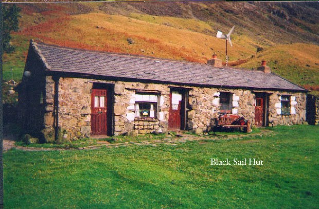
The weather had cleared this morning and was sunny along Ennerdale Lake’s rocky shore and mossy glens. After leaving the lake behind, we came to the very remote Black Sail Hut. The youth hostel was open for tea making and made a good lunch break for us. Earlier, Mary had taught me to save the sausages from the B&B breakfasts to eat for lunch. This seems to be a common practice given the huge breakfasts and since there is usually no place to eat during the day’s walk. Alison had poignant memories of staying at Black Sail 35 years ago when she was a bit younger.
Following the trail up Loft Beck, the C2C path over the mountain, we slowly realized we were on a sheep trod leading away from the beck. Heavy fog and a slight rain greeted us. We made a decision to scramble straight up to the left to find the path again, very difficult through heavy brush on steep terrain. All this in what was now miserable rain and cold which lasted for 3 hours across the mountain to Rosthwaite. At the top, the weather cleared just enough for a magical bird’s eye view of Buttermere Water. Mary was trying out new equipment for a Himalayan trek in Nepal; the rough terrain and weather gave her gear a good workout.
The ladies had a 5 pm bus to catch at Seatoller, going to Keswick for a theater break and rest day. We made it with only ten minutes to spare and, after a fond but hasty farewell, I walked on to my B&B at Stonethwaite. My Ennerdale B&B host had kindly booked it for me. I was soaking wet, but had everything dried in the tumbler. It was too late to book dinner at the Langstrath Hotel but I was able to eat off a simple menu in the bar. Artichoke soup, bread and Hawks Head ale were absolutely wonderful. I spent the evening swapping stories with a local fellow sporting a long, white beard. There is no direct road to Grasmere, the closest large town so to get supplies he makes the walk a couple of times a week. Ten hard miles each way. I'll be going there tomorrow.
Day 3: Friday Oct 15 Stonethwaite to Grasmere
I hooked up with Alan, a surgeon staying at the B&B, for a sunny walk to Grasmere. We climbed up the Borrowdale valley, another scenic, hidden gem, possibly the most beautiful valley in England, but well traveled by walkers. Fall colors were in their glory, reds and yellows, rusts and browns, along the beck and on the enclosing fells. A shepherd on the far side was calling to his flock of sheep. Once out of the valley, it took both our skills to find our way over the rocks, bogs and streams, up over the pass of Greenup Edge, and crossing into the next valley.

Alan went on ahead as I sat on a large boulder to eat lunch. Following Easedale Gill until it becomes a river, it was an easy walk into Grasmere, a welcome bit of civilization. I had time for a cappuccino and a bit of sightseeing, Wordsworth and all. I luckily found lodging at the Fairy Glen B&B (they had a cancellation), and followed what has become a routine, tea, then coffee, then a shower and changing into my pub clothes, then setting my walking clothes out to dry.
At the Red Lion Pub, I had a fabulous vegetable soup with bread and Theakston’s Best Bitters. It’s great fun to try a different ale each night! And the soups are so big and filling that with bread is all I seem to need. I called several lodgings in Patterdale, but they were all full. I will try the TIC in Glenridding (near Patterdale) tomorrow. As has become a pattern, writing and reading ended the night.
Day 4: Sat Oct 16 Grasmere to Patterdale

It was a long, grueling slog up Little Tongue Gill, but there were fantastic views back to Grasmere. Ominous clouds were hanging below the pass, reached by a steep climb up rocky steps. Grisdale Tarn, an alpine-like lake, was spread out beside me. Now a choice of paths. The tough Striding Edge Ridge and St. Sunday Crag paths were completely socked in, so I decided to bypass those higher routes in favor of the rocky, wet descent along the beck into a lovely valley. Taking lunch under a huge tree next to the beck, I had an apple, cheese, sausage, and Richard’s favorite, Kendall Mint Cake - ugghh! Oh well, I got the small one. Then an idyllic walk past daytrippers down into the resort village of Glenridding where I found an internet cafe for my first e-mail home.

Saturday night, the B&B’s were booked up, but the TIC found me a room at the White Lion Inn in Patterdale, two miles from Glenredding and on the C2C path. It was a good move. The local hunting club was meeting in the pub to celebrate their last legal fox hunt before the government ban. They were spending a raucous night drinking and singing Cumberland hunting songs and some of the unique folksongs of Cumbria, even Waltzing Matilda and I Am A Humble Man.
Ohhh, it’s so hard to be humble
When you’re such a perfect man
Can’t wait to look in the mirror
I get better looking every day
It’s so hard to be humble
No matter how hard I try…
The fellow singing Waltzing Matilda sang five minutes of verses before ending with the one we all know. I was impressed! When the leader would point his finger to call on the next singer, each person would stand and sing his piece with everyone joining in on the chorus. One lady with an angelic voice was called on over and over again. Her singing would quiet the rowdy room, taming the savage beasts so to speak. The singing was great fun, but I was ready to duck if the finger pointed my way. Pedigree ale and Whitby shrimp kept me going but I needed my sleep and reluctantly crept upstairs to my room as they were still singing.
Day 5: Sun Oct 17 Patterdale to Shap
Next morning for breakfast, I finagled a huge and tasty Cumberland sausage with my eggs and saved half of it, a la Mary, for lunch with a baguette from the shop across the road. Regretfully, I didn’t carry a camera on this trip, so I bought several postcards, one of the White Lion Inn.
From Patterdale, the path went straight up 2000 ft. past Angle Tarn to Kidsty Pike with wonderful views of Ulswater to the north and valley views to the south. Higher up, I’m in the clouds again, cold and wet, High Street not to be seen. At the cairn on top of Kidsty, I couldn’t see a thing - even my glasses fogged up as the trail disappeared. I met two other lost souls looking at their map, walking east to west. We used my compass to find the path again. I pointed them where I came and they pointed the way for me. The descent to Haweswater was so steep I felt like using a rope, lowering myself rock to rock. Then around the lake and over pasture and stile to Shap. It was very hard to follow Wainwright’s directions in his book., I’ll have to talk to him about that!
The Hermitage B&B was a blessing and Jeanne a godsend washing all my clothes. I settled right in to this 300 year old beamed ceiling house with the huge bedrooms and sunken bathrooms. It was a perfect place to soak my weary muscles and sore toes. Dinner was at an uninteresting pub but the chicken korma with rice and Thwaites ale was exceptionally good.
Day 6: Mon Oct 18 Shap to Kirkby Stephen
The walk to Kirkby Stephen was a too long 20 miles, so I took the 9:30 bus to Orton, 8 miles away, to pick up the path there. Sun passing through the low hanging clouds in the valley, highlighting rooftops covered in light mist, was truly magical. Nice day over hill and dale and my first Yorkshire moors. Nice day, except for being chased through a pasture by a herd of bulls!! The pasture had over a dozen of the huge beasts and, after crossing the stile into their territory, they quickly started bearing down on me! I turned sharply and loudly yelled NO! They stopped and I continued walking. But shortly I heard the clump, clump, clump of their hooves, so I repeated the NO and they stopped again. This went on at least 10 times and was getting quite scary. They were converging on me from the side and the rear until I finally made the stile at the far end of the pasture and heaved a sigh of relief. Perhaps they only thought I was there to feed them.
Across the heather moors I lost the path, consulted compass and contour lines and altitudes in Wainwright, struck off to my right, climbed over a wall, headed for a likely stile and low and behold, there was the path. Later, I couldn’t find the way again. Two other walkers came up and were at a loss also. I then found a solution and they happily followed. We were definitely out of the Lakeland area, transiting into the Yorkshire Dales. Lots of ups and downs but not the ruggedness of previous days. I’m learning to follow the map better but it’s actually harder to negotiate the farms and ranches. Then, all of a sudden, civilization - it seems so strange!
Kirkby is the first real town since Whitehaven and has a bank, nice shops, and a wide choice of B&B’s. I I was lucky to find a room at The Old Croft House, a 250 year old jewel and very professionally run. Chris, the B&B host, greeted me with tea and scones while dinner at the King’s Arm Pub served a welcome moussaka with Sheep’s Head Ale. Chris called ahead for a room in Keld, but all B&B’s were closed for the season. She finally found a room for me at the Kearton Country Hotel in Thwaite, two miles from Keld. As usual, I ended the night writing and reading.
Day 7: Tues Oct 19 Kirkby Stephen to Thwaite
Breakfast was poached eggs, blood pudding, sausage, tomato and mushrooms, with toast and coffee. Wonderful! But there is an ominous sky today. I was at an internet pastry cafe at 9 am for my e-mail, then I left town by Frank’s Bridge.
The weather was daunting on the way to Nine Standards Rigg (at 2200 ft.) and I considered going the lower winter route. However, just where the paths split, I met two stalwart sisters who gave me confidence to go the higher, infamously boggy route.

We had a great walk together, cursing the bogs the whole way. The bogs were as bad as I have found in Ireland. I almost lost my boot in one! Rachel took the requisite photographs at Nine Standards (1000 year old stone columns) for us all. No one knows why they were built. Maybe a pet project of a retired stone wall builder!! This is the eastern edge of the Lake District and the last high area I’ll encounter. Grouse were being flushed as we walked, a popular place for hunters. It was cloudy, cold and windy, but only rained, of course, when we stopped for lunch. We ate in a ruined stone house with one wall standing to buffer the wind. As we traversed lower, stone barns were common. We followed a scenic wild stream with rapids and waterfalls from Ravenseat Farm down to Keld.
Thwaite was only two miles further by road, but the girls were determined to go the much longer Pennine Way path around Kisdon Hill. I opted for the road since it was already 3:45. I’m glad I did! They arrived at the Kearton at 5:30, looking like drowned rats, but satisfied with their accomplishment. I had showered and was full of hot tea by then. Nice hotel, good food, a beautiful dining room overlooking the meadows and fells; it was a bit of luxury in the middle of nowhere. Dinner is mandatory (nowhere else to eat) and includes a dessert table and coffee.
The two sisters: Hattie was an archeologist, now a housewife with kids. Rachel is a publisher of children’s books, a great walker training for a trek in Patagonia. They have been on other walks together, even the Inca Road to Machu Picchu! Ensconced at the hotel were a group of six ladies walking the paths on day trips. They were probably between 65 and 75 years old and full of enthusiasm. Also there were two middle-aged couples and a strangely furtive businessman. I felt like I was in a Poirot TV episode with a dead body turning up at any time. Anything might happen!
Day 8: Wed Oct 20 Thwaite to Reeth
After a great breakfast, the three of us took the river route to Reeth by way of Rampsholme Bridge, Muker and Gunnerside, then the south side of the Swale, following Richard’s river route. By Gunnerside, the weather was cold and rainy, so I treated us all to tea and scones at a cozy tearoom with a blazing fireplace.

No comments:
Post a Comment